
In today’s fast-moving world, accurate mapping is no longer a luxury — it’s a necessity. From building smart cities to improving land surveys and managing large infrastructure projects, precision data is the foundation of smart decisions. This is where Geocue stands out as a trusted name in the world of geospatial technology. With advanced tools that combine software, hardware, expert training, and real-world support, Geocue helps professionals turn complex aerial data into clear, usable information.
Unlike traditional mapping methods that are slow and expensive, modern drone and LiDAR technology allows users to capture data quickly and safely. Geocue simplifies this entire process, making it accessible even for teams that are new to advanced mapping. In this article, you will learn what Geocue is, how it works, why industries rely on it, and how it is shaping the future of aerial data collection.
What Is Geocue? A Simple Explanation
Geocue is a technology-focused company that provides complete solutions for collecting, processing, and managing spatial data. It specializes in LiDAR and drone-based mapping systems, which are used to scan landscapes, buildings, roads, forests, and much more.
Instead of offering just one type of product, Geocue delivers an entire ecosystem. This includes intelligent software for data processing, powerful mapping hardware, professional guidance, and training programs. The goal is simple: help users move from raw data to accurate results without unnecessary complexity.
What makes Geocue unique is how it merges user-friendly designs with high-level technical accuracy, making it suitable for both beginners and experienced professionals.
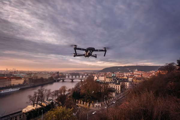
Understanding LiDAR and Drone Mapping in Easy Words
To fully understand the value of Geocue, it helps to know what LiDAR and drone mapping are.
LiDAR is a remote sensing technology that uses laser pulses to measure distances between the sensor and the ground. These pulses reflect back and create highly accurate 3D models of the environment.
Drone mapping involves using unmanned aerial vehicles equipped with cameras or sensors to capture aerial images and data. When combined with LiDAR, drones can gather detailed information about terrain, structures, and vegetation in a very short time.
Geocue brings these two powerful technologies together and makes them easy to use for real-world projects.
How Geocue Helps Professionals Work Smarter
Geocue is not just about flashy technology; it is about solving real problems. Surveyors, engineers, construction managers, and environmental scientists use Geocue tools to reduce manual work and increase accuracy.
With Geocue solutions, users can plan flights, collect data, process that data, and create reports without needing multiple complicated systems. This reduces human error and saves valuable time. The smart integration between tools ensures smooth workflows from start to finish.
Industries That Benefit from Geocue Technology
Many industries rely on Geocue every day to complete critical projects.
In construction, Geocue helps teams measure land, monitor progress, and ensure designs match real-world conditions. In forestry, experts use it to analyze tree height, canopy density, and land health. For transportation, mapping roads, bridges, and railways becomes much safer and more efficient with aerial data.
Even sectors like mining, agriculture, and disaster management benefit from Geocue by gaining clear visibility into complex environments that are difficult to access manually.
Geocue Software: Turning Raw Data into Clear Insights
One of the strongest parts of Geocue is its intelligent software. This software transforms raw LiDAR and drone data into meaningful maps, models, and measurements.
Instead of spending weeks processing complex datasets, users can automate many steps. Noise removal, point cloud classification, and surface modeling become faster and more reliable. The software is designed with simple interfaces, so users do not feel overwhelmed by technical features.
This balance between power and simplicity makes Geocue software highly valued by professionals.
Geocue Hardware: Built for Accuracy and Durability
Geocue also provides advanced hardware that is designed to perform in real-world conditions. These devices are built to be lightweight, durable, and highly accurate.
Whether mounted on drones, vehicles, or handheld systems, Geocue hardware captures precise measurements even in challenging environments. The hardware and software are designed to work seamlessly together, which reduces compatibility issues and ensures smoother operations in the field.
Training and Support: A Key Part of Geocue’s Strength
Many technology platforms fail because users are left alone to figure things out. Geocu’e takes a different approach by offering strong training and support.
Through guided learning, workshops, and expert advice, users can quickly understand how to operate systems and improve their skills. Ongoing support ensures that even complex challenges are handled smoothly. This human-focused approach makes Geocu’e not just a tool provider, but a trusted long-term partner.
Why Geocue Is Trusted for High-Accuracy Projects
Accuracy matters when mapping highways, planning cities, or analyzing environmental change. A small error can lead to costly mistakes.
Geocue’s systems are designed to reduce these risks by combining precision sensors with intelligent processing. The results are consistent, reliable, and easy to verify. This high level of trust makes Geocu’e a preferred choice for projects where quality cannot be compromised.
Geocue and the Future of Mapping Technology
The future of mapping is becoming more automated, faster, and more intelligent. Geocu’e is playing an important role in this evolution by constantly improving its systems.
With the integration of artificial intelligence, cloud processing, and real-time analytics, mapping is moving towards instant insights. Geocu’e is preparing users for this future by offering flexible systems that grow with advancing technology. This forward-thinking approach keeps it relevant in a rapidly changing industry.
How Geocue Simplifies Complex Workflows
Before tools like Geocu’e, capturing and processing spatial data required multiple disconnected systems. This often led to confusion, delays, and data loss.
Geocu’e simplifies everything by connecting planning, capture, processing, and reporting into one smooth workflow. Users do not have to jump between different platforms. This seamless experience boosts productivity and reduces stress, especially for teams handling large-scale projects.
Real-World Use Cases of Geocue in Action
In real-world situations, Geocu’e has proven its value across countless projects. Survey teams use it to quickly assess land before development. Environmental researchers rely on it to monitor changes in forests and coastlines. Utility companies use it to inspect power lines and pipelines without putting workers at risk.
These real-life applications show that Geocu’e is not just a technical solution but a practical tool that makes difficult jobs easier and safer.
Benefits of Choosing Geocue for Mapping Projects
Organizations choose Geocu’e because it increases speed, improves safety, and delivers dependable results. Faster data collection means quicker project completion. Safer methods mean fewer on-site risks. Better data quality means stronger decision-making.
These advantages combine to create a solution that not only saves time and money but also improves overall project confidence.
Geocue vs Traditional Mapping Methods
Traditional mapping methods often rely on manual measurements, which can be time-consuming and less accurate. They also require teams to physically access dangerous or hard-to-reach locations.
Geocu’e changes this by allowing data to be captured from the air or through mobile systems. This reduces physical risk and dramatically improves efficiency. Compared to older techniques, the modern approach powered by Geocu’e is clearly more effective and reliable.
Conclusion
Geocue has transformed how professionals handle mapping and spatial data. By combining advanced technology with user-friendly systems, it makes complex work simple and efficient. From software and hardware to training and support, Geocu’e delivers a complete solution that helps users achieve accurate results faster and safer.
As industries continue to depend on data-driven decisions, tools like Geocu’e will play an even bigger role. Whether for small projects or large-scale developments, Geocu’e stands as a powerful partner in modern mapping success.
FAQs
What is Geocue used for?
Geocue is used to collect, process, and manage LiDAR and drone mapping data for accurate spatial results.
Is Geocue suitable for beginners?
Yes, Geocue offers user-friendly tools along with training that helps beginners learn quickly.
Does Geocue only work with drones?
No, it also works with vehicle-mounted and handheld mapping systems.
Can Geocue be used for large projects?
Yes, it is designed to handle both small tasks and large-scale professional projects.
Does Geocue provide customer support?
Yes, it offers strong technical support and expert guidance for users.
Is Geocue technology future-ready?
Yes, Geocue continuously evolves its systems to stay aligned with future mapping trends.